USGS Coastal and Marine Hazards and Resources Program
By E. Robert Thieler¹, Emily A. Himmelstoss¹, Jessica L. Zichichi², and Ayhan Ergul²
¹Coastal and Marine Geology Program, U.S. Geological Survey, Woods Hole, MA 02543
²Innovate! Inc., 5835 Valley View Drive, Alexandria, Virginia 22310
Published 2009
If you use the DSAS extension, please cite the following publication:
Thieler, E.R., Himmelstoss, E.A., Zichichi, J.L., and Ergul, Ayhan, 2017, Digital Shoreline Analysis System (DSAS) version 4.0—An ArcGIS extension for calculating shoreline change (ver. 4.4, July 2017): U.S. Geological Survey Open-File Report 2008-1278.
The current version is 4.4 and is compatible with ArcGIS 10.4 and 10.5. Revised July 2017
The following files are available for download:
required_MCRinstaller.zip (228 Mb) – MATLAB Component Runtime Utility installer (please see DSAS user guide for more information)
DSASAddin_v4.4.zip (5 Mb) - the DSAS installer package, compressed Esri add-in file
DSASv4_4_manual.pdf (3.3 Mb) - Adobe PDF user guide includes installation instructions.
DSASv4.4_sample_data.zip (188 kb) - Sample ArcGIS 10 geodatabase, compressed zip file.
For more information, contact:
Emily Himmelstoss
ehimmelstoss@usgs.gov
tel: 508-457-2262
This version is 4.3.4730 and is compatible with ArcGIS 10 and 10.1. This version will remain available for users, but is unsupported. Revised April 2012
The following files are available for download:
required_MCRinstaller.zip (228 Mb) – MATLAB Component Runtime Utility installer (please see DSAS user guide for more information)
DSASv4.3.4730.zip (2.1 Mb) - the DSAS installer package, compressed zip file
DSASv4_3.pdf (3.3 Mb) - Adobe PDF user guide includes installation instructions.
DSASv4.3_sample_data.zip (226 kb) - Sample ArcGIS 10 geodatabase, compressed zip file.
For more information, contact:
Emily Himmelstoss
ehimmelstoss@usgs.gov
tel: 508-457-2262
This version will remain available for users without access to ArcGIS v.10, but is unsupported. Revised August 2010
The following files are available for download:
required_MCRinstaller.zip (228 Mb) – MATLAB Component Runtime Utility installer (please see DSAS user guide for more information)
DSASv4.2.zip (2.0 Mb) - the DSAS installer package, compressed zip file
DSASv4_2.pdf (2.8 Mb) - Adobe PDF user guide includes installation instructions.
DSAS_sample_data.zip (254 kb) - Sample ArcGIS 10 geodatabase, compressed zip file.
The Digital Shoreline Analysis System (DSAS) version 4.4 is a software extension to Esri ArcGIS v.10.4 and 10.5 that enables a user to calculate shoreline rate-of-change statistics from multiple historic shoreline positions. A user-friendly interface of simple buttons and menus guides the user through the major steps of shoreline change analysis. Components of the extension and user guide include (1) instruction on the proper way to define a reference baseline for measurements, (2) automated and manual generation of measurement transects and metadata based on user-specified parameters, and (3) output of calculated rates of shoreline change and other statistical information. DSAS computes shoreline rates of change using four different methods: (1) endpoint rate, (2) simple linear regression, (3) weighted linear regression, and (4) least median of squares. The standard error, correlation coefficient, and confidence interval are also computed for the simple and weighted linear-regression methods. The results of all rate calculations are output to a table that can be linked to the transect file by a common attribute field. DSAS is intended to facilitate the shoreline change-calculation process and to provide rate-of-change information and the statistical data necessary to establish the reliability of the calculated results. The software is also suitable for any generic application that calculates positional change over time, such as assessing rates of change of glacier limits in sequential aerial photos, river edge boundaries, land-cover changes, and so on.

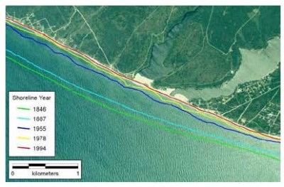
Historic shorelines for a portion of southwestern Nantucket Island, Massachusetts.

Historic shorelines and DSAS-generated transects at 100-meter spacing with histogram showing rates of shoreline change computed using simple linear regression.
Neither the U.S. Government, the Department of the Interior, nor the USGS, nor any of their employees, contractors, or subcontractors, make any warranty, express or implied, nor assume any legal liability or responsibility for the accuracy, completeness, or usefulness of any information, apparatus, product, or process disclosed, nor represent that its use would not infringe on privately owned rights. The act of distribution shall not constitute any such warranty, and no responsibility is assumed by the USGS in the use of these data or related materials.
Any use of trade, product, or firm names is for descriptive purposes only and does not imply endorsement by the U.S. Government.
To view files in PDF format, download a free copy of Adobe Reader.
URL: cmgds.marine.usgs.gov/publications/DSAS/of2008-1278/index.html
Page Contact Information: WHSC Webmaster
This page last modified on Tuesday, 18-Jul-2017 10:04:01 EDT